GARRISONNEW YORK |
 |
GARRISONNEW YORK |
|
The town of Garrison is severed by Amtrak. Noisy, high-speed trains occasionally zoom through the middle of what is normally a very quiet little town. If you’re anywhere near the tracks when one comes through, it will scare you half-to-death.
 Private
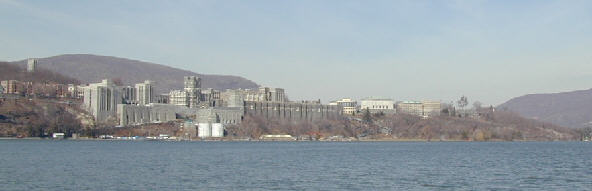
property restricts access to the Hudson River, but look for a pagoda where the
public is invited. From the pagoda, the United States Military Academy can be
seen clearly across the river.
Private
property restricts access to the Hudson River, but look for a pagoda where the
public is invited. From the pagoda, the United States Military Academy can be
seen clearly across the river.
At the “west point” on the Hudson was the site of Fort Arnold, later
renamed Fort Clinton.  Its
strategic position can be clearly seen from Garrison. The fort overlooked the
entire bend that the river makes at this point.
Its
strategic position can be clearly seen from Garrison. The fort overlooked the
entire bend that the river makes at this point.
In 1778, a second, “great chain” was stretched across the Hudson at West
Point. Links from the actual chain can be seen at West Point. There is also a
marker at the point that tells about the chain.
| The Great Chain
The Hudson River’s narrow width and sharp turns at West Point created adverse sailing conditions and prompted construction of a great chain in 1778 as an obstacle to the movement of British ships north of this point. American soldiers positioned the chain to impede the progress of a ship should it attempt to turn into the east-west channel against frequently unfavorable winds and a strong current. Cannon were placed in forts and batteries on both sides of the river to destroy the ship as it slowed to a halt against the obstacle. When finally completed, the 600-yard chain contained iron links two feet in length and weighing 114 pounds, including swivels, clevises, and anchors, the chain weighed 65 tons. For buoyancy, 40-foot logs were cut into 16-foot sections, waterproofed, and joined by fours into rafts fastened with 12-foot timbers. Short sections of chain (ten links and a clevis) were stapled across each raft. Later the chain sections were united. On 30 April 1778, Captain Thomas Machin, the engineer responsible for assembling and installing the obstruction, eased the chain across the river, anchoring its northern end under the protection of Marine Battery on Constitution Island. The southern end was secured in a small cove guarded by Chain Battery at the river’s edge. Both ends were anchored to log cribs filled with rocks. A system of pulleys, rollers, ropes, and mid-stream anchors adjusted the chain’s tension to overcome the effects of river current and changing tide. Until 1783, the chain was removed each winter and reinstalled each spring to avoid destruction by ice. A log “boom” (resembling a ladder in construction) also spanned the river about 100 yards downstream to absorb the initial impact of a ship attempting to penetrate the barrier. Several links of the chain are located at trophy point. A section of the boom was recovered from the river in 1855 and is on display at Washington’s headquarters museum in Newburgh. The British fleet never approached West Point, and the strength of the great chain was never tested. (West Point Marker) |
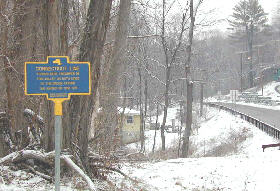
Connecticut Line Marker -- This area was part of the American defense set up in the Highlands during the Revolution.
| Connecticut
Line
Troops were encamped in this valley on both side of the brook during the winter of 1780-1781. State Education Department (Nelsonville Marker) |
|