|
 Fasten Your Seat Belts for NINE
One-Day Driving Tours (and a Canal Cruise)
that Trace the American Revolution along
America's Most Scenic Highways
Each book is more than 150 pages
in length and provides complete driving directions to dozens of sites as
well as detailed information, markers, photos and maps. Each book also includes
recommendations for places to eat and stay along the way.
Purchase online through EBAY'S PAYPAL.COM
and receive
FREE USPS
Shipping & Handling and NYS Sales Tax Included (if applicable)
|
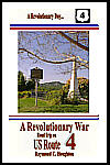  A
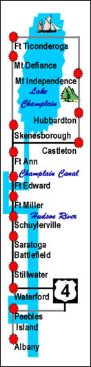
Revolutionary War Road Trip on US Route 4 (ISBN 1-931373-09-4,
Castleton, VT to Albany, NY, 162
pages) traces the British Invasion of 1777 along today's US Route 4. A
Revolutionary War Road Trip on US Route 4 (ISBN 1-931373-09-4,
Castleton, VT to Albany, NY, 162
pages) traces the British Invasion of 1777 along today's US Route 4.
A Revolutionary War Road Trip on US Route 4 begins early
in the morning in Castleton, Vermont, historically on July 7, 1777 when
Major General Arthur St. Clair and about 2,500 American troops retreated
from a British pursuit that began at Fort Ticonderoga the day before.
The American troops would move through Castleton and then travel east to
Rutland, then turn south to Manchester and finally head southwest to
Fort Miller. Just south of Fort Miller, they would be reinforced and
defeat the British at the Battles of Saratoga.
From Castleton you will cross Route 4 and head north on
the old military road through the Hubbardton Battlefield and Mount
Independence, then cross Lake Champlain by ferry to Fort Ticonderoga and
Mount Defiance where on July 4, 1777, Burgoyne moved cannons up to the
top of the mountain and sparked the American retreat.
 You will continue south following the route taken by the
British during the invasion of 1777 through Whitehall, Fort Ann, Fort
Edward, Fort Miller and Schuylerville following the Hudson River to the
Saratoga National Historical Park where the battles of Saratoga took
place, the ôturning point of the American Revolution.ö You will continue south following the route taken by the
British during the invasion of 1777 through Whitehall, Fort Ann, Fort
Edward, Fort Miller and Schuylerville following the Hudson River to the
Saratoga National Historical Park where the battles of Saratoga took
place, the ôturning point of the American Revolution.ö
From the park, you will continue south following the
Hudson River through Stillwater, Waterford and Peebles Island until you
complete your journey in Albany, the target of the British invasion and
home of General Philip Schuyler, the commander of the Northern
Department of the Continental Army.
Look
inside this book at Google Print.
|
|
  A
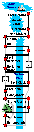
Revolutionary War Road Trip on NY Route 5 (ISBN 1-931373-21-3,
Oswego to Schenectady, NY, 156 pages)
parallels the 1777 British invasion from Lake Ontario. A
Revolutionary War Road Trip on NY Route 5 (ISBN 1-931373-21-3,
Oswego to Schenectady, NY, 156 pages)
parallels the 1777 British invasion from Lake Ontario.
The road trip begins early in the morning at Fort
Ontario in Oswego, NY on Lake Ontario. This is where Lieutenant Colonel
Barry St. Leger and his British forces would begin the invasion.
From Fort Ontario, the road trip heads south by Oneida
Lake and through Bernhard on the way to Fort Stanwix in Rome, NY, where
St. Legerĺs invasion would end.
From Fort Stanwix, the road trip continues south to
the Oriskany Battlefield. This site was where General Nicholas Herkimer
and his Tryon County Militia were ambushed on their way to relieve Fort
Stanwix.
From the Oriskany Battlefield, the road trip turns
east through Utica, Herkimer (Fort Dayton) and Fort Herkimer to the
Herkimer Home, paralleling the route taken by General Herkimerĺs
militia to and from Oriskany.
 From the Herkimer Home, the road trip continues east
through Fort Klock, Fort Plain and Canajoharie and then detours north
through Stone Arabia to Johnstown where Sir William Johnson would sew
the seeds of support for the British cause among the Six Indian Nations. From the Herkimer Home, the road trip continues east
through Fort Klock, Fort Plain and Canajoharie and then detours north
through Stone Arabia to Johnstown where Sir William Johnson would sew
the seeds of support for the British cause among the Six Indian Nations.
From Johnstown, the road trip takes another detour Ś
this time from the Mohawk Valley to the Schoharie Valley, which like the
Mohawk Valley suffered the affects of many raids by British, Tory and
Indian forces.
From Schoharie, the road trip turns east to rejoin the
Mohawk Turnpike in Schenectady. During Colonial times, Schenectady was
the head of navigation on the Mohawk River as rapids and waterfalls lie
to the east where the Mohawk empties into the Hudson River.
|
|
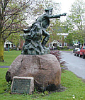
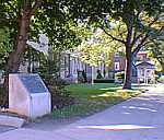
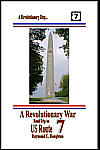 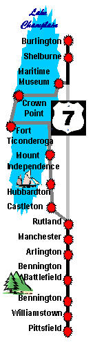 A Revolutionary War Road Trip on US Route 7 (ISBN 1-931373-10-8,
Pittsfield, MA to Burlington, VT, 152
pages) traces
the development of the first overt military action of the American
Revolution ľ the capture of Fort Ticonderoga.
A Revolutionary War Road Trip on US Route 7 (ISBN 1-931373-10-8,
Pittsfield, MA to Burlington, VT, 152
pages) traces
the development of the first overt military action of the American
Revolution ľ the capture of Fort Ticonderoga.
The road trip begins in
Pittsfield (MA) where historically on May 1, 1775 Edward Mott and a
squad of Connecticut volunteers met with John Brown to recruit
volunteers and discuss an assault on Fort Ticonderoga. From Pittsfield,
you will go north along US Route 7 through Williamstown, Massachusetts
to Bennington, Vermont where on May 3, 1775, a platoon of Massachusetts
and Connecticut volunteers met with Ethan Allen and the Green Mountain
Boys.
From Bennington, you will detour slightly to the west to
visit the Bennington Battlefield in Hoosick Falls, New York then return
back to Vermont and travel north along Historic Route 7A (old US Route
7) through Arlington to Manchester. From Manchester, you will continue
north on US Route 7 to Rutland then detour west along Historic Route 4A
to Castleton where on May 9, 1775, a battalion-sized force from Vermont,
Massachusetts and Connecticut would make final plans for an assault on
Fort Ticonderoga.
 From Castleton you will head north on the old military
road making visits to the Hubbardton Battlefield and Mount Independence,
then cross Lake Champlain by ferry to Fort Ticonderoga, New York where
early in the morning on May 10, 1775, British Captain Delaplace would
surrender the fort to Ethan Allen after a surprise attack by American
forces. From Castleton you will head north on the old military
road making visits to the Hubbardton Battlefield and Mount Independence,
then cross Lake Champlain by ferry to Fort Ticonderoga, New York where
early in the morning on May 10, 1775, British Captain Delaplace would
surrender the fort to Ethan Allen after a surprise attack by American
forces.
From Fort Ticonderoga, you will resume a northerly
direction on the west side of Lake Champlain up to Crown Point. After
crossing the bridge over Lake Champlain, you will travel up the east
side of the lake to the Lake Champlain Maritime Museum, then work your
way back to US Route 7 and finish your tour in Burlington, Vermont where
in 1787, Ethan Allen and his wife, Fannie, would settle into their final
home.
Look
inside this book at Google Print.
|
|
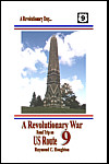  A Revolutionary War Road Trip on US Route 9 (ISBN 1-931373-12-4,
Kings Ferry to Saratoga Springs, NY, 166
pages) traces
the many British attempts to gain control of the Hudson River during the
Revolutionary War.
A Revolutionary War Road Trip on US Route 9 (ISBN 1-931373-12-4,
Kings Ferry to Saratoga Springs, NY, 166
pages) traces
the many British attempts to gain control of the Hudson River during the
Revolutionary War.
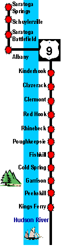
The road trip begins at Kings Ferry, a major crossing
point on the Hudson. Because the British controlled New York City, Kings
Ferry was the southernmost crossing point for American personnel and
supplies for most of the war.
From Kings Ferry, the road trip heads north through
Peekskill, Garrison and Cold Spring to Fishkill, which was the site of a
large supply depot for the northern department of the Continental Army.
From Fishkill, the road trip continues north through
Poughkeepsie, Rhinebeck and Red Hook to Clermont, which was the furthest
north Clintonĺs 1777 invasion from New York City reached.
 From Clermont, the road trip continues north through
Claverack and Kinderhook and crosses the Hudson River to Albany, which
was the target for the British invasions of 1777. From Clermont, the road trip continues north through
Claverack and Kinderhook and crosses the Hudson River to Albany, which
was the target for the British invasions of 1777.
From Albany, the road trip continues north to the
Saratoga Battlefield, where Burgoyneĺs invasion from the north would
be stopped.
From Saratoga, the road trip continues north to
Schuylerville, where Burgoyne surrendered, and then from Schuylerville,
the road trip concludes in Saratoga Springs.
Look
inside this book at Google Print.
|
|
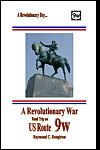 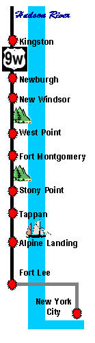 A Revolutionary War Road Trip on US Route 9W (ISBN 1-931373-11-6,
New York City to Kingston, NY, 174 pages) traces British efforts to
divide the American colonies along the Hudson River. The road trip
begins early in the morning in New York City about thirteen miles south
of the start of US Route 9W. New York City is where the battle for
control of the Hudson began in 1775 and sets the stage for the sites
that will be visited during the rest of the day.
A Revolutionary War Road Trip on US Route 9W (ISBN 1-931373-11-6,
New York City to Kingston, NY, 174 pages) traces British efforts to
divide the American colonies along the Hudson River. The road trip
begins early in the morning in New York City about thirteen miles south
of the start of US Route 9W. New York City is where the battle for
control of the Hudson began in 1775 and sets the stage for the sites
that will be visited during the rest of the day.
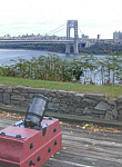
From New York City, the road trip goes north along Route
9A to the George Washington Bridge and crosses the Hudson to Fort Lee,
New Jersey. In November 1776, Washington was forced to watch from Fort
Lee as about 3,000 of his men on the opposite side of the Hudson succumb
to heavy fire from about 15,000 British troops.
 From Fort Lee, the road trip continues north to Alpine
Landing then to Tappan, George Washingtonĺs Headquarters on four
separate occasions. From Tappan, the road trip continues north to Stony
Point, the site of a daring midnight assault by Americans in 1779. After
Stony Point, the road trip follows Route 9W to Fort Montgomery and then
to West Point, home of the United States Military Academy. Many of the
fortifications and weapons used by the American forces to protect the
Hudson River still remain today at West Point. From Fort Lee, the road trip continues north to Alpine
Landing then to Tappan, George Washingtonĺs Headquarters on four
separate occasions. From Tappan, the road trip continues north to Stony
Point, the site of a daring midnight assault by Americans in 1779. After
Stony Point, the road trip follows Route 9W to Fort Montgomery and then
to West Point, home of the United States Military Academy. Many of the
fortifications and weapons used by the American forces to protect the
Hudson River still remain today at West Point.
From West Point, the road trip continues north to New
Windsor, the final encampment for the American forces, and then to
Washingtonĺs final headquarters at Newburgh. He would spend almost 18
months at this headquarters Ś more time than he would spend at any
other headquarters throughout the war.
From Newburgh, the road trip continues north on Route
9W and concludes in Kingston. In 1777, the British would torch the city,
but many Revolutionary War era, stone homes still stand today in the
Kingston Stockade.
Look
inside this book at Google Print.
|
|
 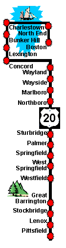 A Revolutionary War Road Trip on US Route 20 (ISBN 1-931373-19-1,
Pittsfield to Boston, MA, 180 pages)
parallels colonial routes taken during the war by George Washington,
Henry Knox, Paul Revere and the soldiers of Shaysĺ Rebellion.
A Revolutionary War Road Trip on US Route 20 (ISBN 1-931373-19-1,
Pittsfield to Boston, MA, 180 pages)
parallels colonial routes taken during the war by George Washington,
Henry Knox, Paul Revere and the soldiers of Shaysĺ Rebellion.
The road
trip begins at Pittsfield, Massachusetts where in the late fall of 1775,
Henry Knox passed through the village on his way to organize a
transportation unit in New York to carry the cannons captured at Fort
Ticonderoga to Boston.
From Pittsfield, the road trip heads south through
Lenox and Stockbridge and then west to the New York State border to pick
up the Knox Trail to Great Barrington. Along the trail is the site of
the last battle of Shaysĺ Rebellion.
From Great Barrington, the road trip crosses over the
scenic Berkshire Mountains through Monterey, Otis and Blandford to
Westfield where Knox celebrated the near completion of his
transportation mission, an ordeal that many called impossible.
From Westfield, the road trip heads east through West
Springfield to Springfield, which was the home of a colonial armory that
made Springfield a Revolutionary War crossroad.
 From Springfield, the road trip continues east through
Wilbraham, Palmer, Brimfield, Sturbridge, Charlton, Oxford, Auburn,
Worcester, Shrewsbury, Northborough, Marlborough to Sudbury and the
Wayside Inn where the gathering of patriots and guests have been
immortalized by Longfellowĺs Tales of a Wayside Inn. From Springfield, the road trip continues east through
Wilbraham, Palmer, Brimfield, Sturbridge, Charlton, Oxford, Auburn,
Worcester, Shrewsbury, Northborough, Marlborough to Sudbury and the
Wayside Inn where the gathering of patriots and guests have been
immortalized by Longfellowĺs Tales of a Wayside Inn.
From Sudbury, the road trip takes a turn to the north
through Wayland and by Walden Pond to Concord, which was a target of a
British penetration on April 19, 1775.
From Concord, the road trip heads east along the ôBattle
Roadö from Concord through Lexington and Arlington to Bunker Hill,
where Americans would try to stop British expansion around Boston.
From Bunker Hill, the road trip concludes with a walk
along the Freedom Trail through Charleston and the North End to downtown
Boston passing by many of Bostonĺs historic colonial sites including,
Old North Church, the Paul Revere House, Faneuil Hall, the Old State
House, the Old South Meeting House, Granary Burying Ground and Boston
Common.
|
|
  A Revolutionary War Road Trip on US Route
60 (ISBN 1-931373-20-5, Charlottesville to Yorktown, VA, 110 pages)
tracks the end of the British Southern Campaign across Virginia. The
campaign began with three invasions of Virginia by sea and ended with a
fourth invasion from the south by land. A Revolutionary War Road Trip on US Route
60 (ISBN 1-931373-20-5, Charlottesville to Yorktown, VA, 110 pages)
tracks the end of the British Southern Campaign across Virginia. The
campaign began with three invasions of Virginia by sea and ended with a
fourth invasion from the south by land.
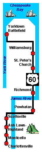
The road trip begins at the University of Virginia and
downtown Charlottesville, where an early warning allowed the Governor of
Virginia, Thomas Jefferson, and most of the Virginia Assembly to escape
British capture.
From Charlottesville, the road trip heads south to the
James River with stops at Monticello, the home of Thomas Jefferson and
Ash Lawn-Highland, the home of President and Revolutionary War Officer,
James Monroe.
 After crossing the James River at Scottsville, the
road trip joins US Route 60 and turns east through Powhatan to Richmond,
the capital of Virginia from 1780 to present. Before Richmond became the
capital, it hosted the Second Virginia Convention in March 1775. During
the convention, Patrick Henry delivered his famous ôLiberty or Deathö
speech, which echoed throughout the thirteen colonies and became the
clarion call to revolution. After crossing the James River at Scottsville, the
road trip joins US Route 60 and turns east through Powhatan to Richmond,
the capital of Virginia from 1780 to present. Before Richmond became the
capital, it hosted the Second Virginia Convention in March 1775. During
the convention, Patrick Henry delivered his famous ôLiberty or Deathö
speech, which echoed throughout the thirteen colonies and became the
clarion call to revolution.
From Richmond, the road trip continues east through
New Kent to Williamsburg, the second capital of Virginia and center of
Revolutionary War activities for most of the war. Today, Colonial
Williamsburg is one of the oldest and largest living history museum.
From Williamsburg, the road trip continues east along
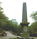
the Colonial Parkway to the Yorktown battlefield. In October 1781, the
last major battle of the Revolutionary War would be fought here.
|
|
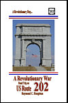  A Revolutionary War Road Trip on US Route 202 (ISBN
1-931373-13-2, Elkton, MD to Philadelphia, PA, 154 pages) parallels the 1777 British invasion from
Chesapeake Bay.
A Revolutionary War Road Trip on US Route 202 (ISBN
1-931373-13-2, Elkton, MD to Philadelphia, PA, 154 pages) parallels the 1777 British invasion from
Chesapeake Bay.
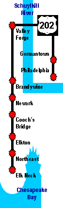
The road trip begins early in the morning at Elk Neck,
Maryland at the overlook of General Howeĺs landing. From Elk Neck, the
road trip heads north through Northeast and Elkton to Coochĺs Bridge,
where American forces set up an ambush and briefly engaged the invading
British forces.
From Coochĺs Bridge, the road trip continues north
through Newark to Brandywine, where American forces set up a major
defensive position, but would retreat after being out-flanked by the
British.
From Brandywine, the road trip continues north to
Valley Forge, where the defeated American forces would be greeted by a
punishing winter,  but would emerge in the spring as a well-trained,
hardened army, ready for battle. but would emerge in the spring as a well-trained,
hardened army, ready for battle.
From Valley Forge, the road trip continues east to
White Marsh, then south through Germantown to Philadelphia, the target
of the British invasion from Chesapeake Bay.
Look
inside this book at Google Print. |
|
 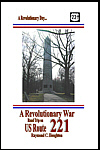 A
Revolutionary War Road Trip on US Route 221 (ISBN 1-931373-18-3,
Chesnee, SC to Augusta, GA, 160 pages) tracks the loss of the southern
Backcountry by Great Britain and her Loyalists to American
Patriots. A
Revolutionary War Road Trip on US Route 221 (ISBN 1-931373-18-3,
Chesnee, SC to Augusta, GA, 160 pages) tracks the loss of the southern
Backcountry by Great Britain and her Loyalists to American
Patriots.
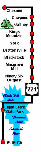
The road trip begins early
in the morning on Route 221 in Chesnee, SC, a site on the Overmountain Victory
National Historic Trail. From Chesnee, the road trip heads east to the Cowpens
National Battlefield where American troops under Brigadier General Daniel Morgan
won a major victory over a British force commanded by Lieutenant Colonel
Banastre Tarleton.
From Cowpens, the road trip heads south through Gaffney to the
Kings Mountain National Military Park where there was another major American
Victory by the Overmountain Men over Loyalist forces under Patrick Ferguson.
From Kings Mountain the road trip continues south through York,
Historic Brattonsville, the Blackstock Battlefield and Musgrove Mill to the 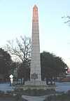 Ninety Six National Historic Site, which was an important British outpost that
was abandoned after Americaĺs longest siege of the Revolutionary War.
Ninety Six National Historic Site, which was an important British outpost that
was abandoned after Americaĺs longest siege of the Revolutionary War.
From Ninety Six, the road trip crosses the Savannah River into
Georgia for a visit to the Elijah Clark State Park. The road trip concludes in
Augusta, which was the Revolutionary War capital of Georgia that changed hands
several times during the war.
|
|
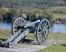
  A Revolutionary War Cruise on the Champlain Canal (ISBN
1-931373-14-0, Bethlehem, NY to Vergennes, VT, 160 pages)
traces the many British attempts to gain control of the valleys of the
Hudson River and Lake Champlain during the Revolutionary War. The book
provides complete navigation to dozens of sites as well as
recommendations for places to dock along the way.
A Revolutionary War Cruise on the Champlain Canal (ISBN
1-931373-14-0, Bethlehem, NY to Vergennes, VT, 160 pages)
traces the many British attempts to gain control of the valleys of the
Hudson River and Lake Champlain during the Revolutionary War. The book
provides complete navigation to dozens of sites as well as
recommendations for places to dock along the way.
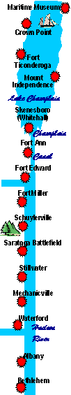
The seven-day cruise begins on the Hudson River
opposite the town of Bethlehem, NY, just south of Albany. From
Bethlehem, you will sail past many areas where 18th century patriots
once lived. When you arrive in Albany, you will dock at the Corning
Preserve and take a short walking tour of Albanyĺs Revolutionary War
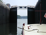
sites. From Albany, you will continue sailing north through the Federal
Lock in Troy and Locks 1 and 2 on the Champlain Canal to Mechanicville
where you will dock for the evening.
On Day 2, you will continue sailing north through
Locks 3 and 4 and anchor offshore near the Saratoga Battlefield where
you will take a short walking tour of the Great Redoubt. From the
battlefield, you will continue sailing north through Locks 5 and 6 to
Fort Edward where you will dock for the evening and visit the old fortĺs
historical sites. Burgoyne headquartered at Fort Edward during his
invasion.
On Day 3, you will continue sailing north through
Locks 7, 8, 9 and 11 (Lock 10 was never constructed) to Whitehall where
you will dock for a visit to the Skenesborough Museum. From the museum,
you will continue sailing north through Lock 12 to a marina near Mount
Independence where you will dock for the evening and make arrangements
to visit Mount Independence. The fort at Mount Independence was
evacuated and destroyed by the Americans when Burgoyne hauled cannons to
the top of Mount Defiance, opposite the fort.
On Day 4, you will continue sailing north on Lake
Champlain and anchor near Fort Crown Point where you will take a walking
tour of the old ruins. Fort Crown Point and nearby Fort Ticonderoga were
captured from the British in 1775. Americans under the command of Henry
Knox moved cannons and munitions from the forts to force the British
from Boston in 1776. From Fort Crown Point, you will continue sailing
north to the Lake Champlain Maritime Museum. After a visit to the
museum, you will sail across Lake Champlain and dock at Westport for the
evening.
On Day 5, you will reverse direction and sail south
and anchor near Fort Ticonderoga for a visit to the restored fort.
Because of its commanding presence over the southern part of Lake
Champlain, the fort was called ôa Key to a Continent.ö After touring
the fort, you will continue sailing south and dock at a marina in
Whitehall for the evening and visit historical sites at the ôBirthplace
of the US Navy.ö
 On Day 6, you will continue sailing south through
Locks 12 and 11 and dock at Fort Ann where you will visit the historic
town. Fort Ann was the source of significant resistance to Burgoyneĺs
invasion in 1777. After a walk around town, you will continue sailing
south through Locks 9, 8, 7, 6 and 5 and dock at a marina in
Schuylerville for the evening. While in Schuylerville, you will take a
walking tour of the town where Burgoyne officially surrendered his army
to the Americans. On Day 6, you will continue sailing south through
Locks 12 and 11 and dock at Fort Ann where you will visit the historic
town. Fort Ann was the source of significant resistance to Burgoyneĺs
invasion in 1777. After a walk around town, you will continue sailing
south through Locks 9, 8, 7, 6 and 5 and dock at a marina in
Schuylerville for the evening. While in Schuylerville, you will take a
walking tour of the town where Burgoyne officially surrendered his army
to the Americans.
On Day 7, you will continue sailing south through Lock
4 and dock for a visit to Stillwater. Stillwater was a former
headquarters to the Northern Department of the Continental Army. After a
walk around town, you will continue sailing south through Locks 3, 2 and
1 to Waterford. After docking in Waterford, you will conclude your
Revolutionary War Cruise on the Champlain Canal with a visit to this
historic gateway to the Champlain and Erie Canals.
Look
inside this book at Google Print.
|
|
You can also order Print-On-Demand copies of the
Revolutionary War Road Trip books through
AMAZON.COM'S BOOKSURGE DIVISION
at their toll free number, 1-866-308-6235
or online at www.amazon.com.
MORE BOOK OFFERS
AVAILABLE ONLINE THROUGH EBAY'S
PAYPAL.COM ONLY |
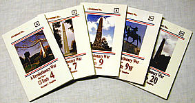 THE NORTHEAST ROAD TRIP SET --
The Set includes the US Route 4, US Route 7, US Route 9, US Route 9W and
US Route 20 Revolutionary War
Road Trip Books. The Set is only $49.95 - A $15 savings over the total cover price
for all five books. THE NORTHEAST ROAD TRIP SET --
The Set includes the US Route 4, US Route 7, US Route 9, US Route 9W and
US Route 20 Revolutionary War
Road Trip Books. The Set is only $49.95 - A $15 savings over the total cover price
for all five books.
|
|
ABOUT THE AUTHOR: Raymond C.
Houghton was a retired college professor, former Federal Government staff
member, Vietnam Veteran and one-time, General Electric employee. He held
honors from the Department of Commerce, is listed in Whoĺs Who in
America, holds a doctorate from Duke University and was the historian for
the Town of Bethlehem, NY. His goal was to get people out on our historic
highways to relive and appreciate an important time in American history. Dr. Houghton passed away in 2007, and the world lost a truly remarkable person. His family now sells his books. We appreciate the support for his books and sharing in his love of Revolutionary History.
|
|