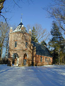
ST. PETER'S CHURCHNEW KENT, VIRGINIA |
 |
ST. PETER'S CHURCHNEW KENT, VIRGINIA |
|
 |
St. Peter’s Parish Church (Episcopal) Parish created, 1679. Church erected, 1704. The first church of the first First-Lady. (St. Peter’s Marker) |
St. Peter’s Parish Church is among the oldest congregations in America with its establishment in 1679. The current church building was begun in 1701 and was in use by 1703. St. Peter’s is the oldest church in the state.
The church is often called “the first church of the first lady” because Martha Dandridge, who would later become the wife of George Washington, was a member. In June 1749, she had originally married Colonel Daniel Parke Custis, a former churchwarden and vestryman, but was widowed by 1757.
Two years later, Martha would marry Colonel George Washington on January 6, 1759. The church rector, the Reverend David Mossom, presided over the ceremony.
Today, St. Peter’s remains an active church with two services held each Sunday (9 & 11 AM). In 2003, it celebrated the tercentennial of the construction of the current building.
 |
|
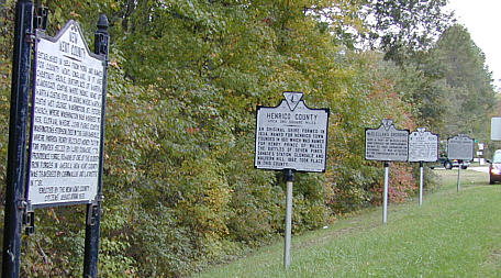
New Kent County Established in 1654 from York and named for County Kent, England. In it are Chestnut Grove, Birthplace of Martha (Dandridge) Custis; White House, home of Martha Custis; Poplar Grove, where Martha Custis met George Washington; St. Peter’s Church, where Washington was married to her; Eltham, where John Parke Custis, Washington’s stepson, died in 1781; Barhamsville, where Patrick Henry received money to pay for powder seized by Lord Dunmore, 1775; Providence Forge, remains of one of the oldest iron forges in America. New Kent County was traversed by Cornwallis and Lafayette in 1781. Erected by the New Kent County Citizens’ Association 1931. (US Route 60 Marker) |
New Kent County Marker -- This marker summarizes the history of the county and upholds a tradition that the Washington-Custis wedding was held at St. Peter’s Church.
The marker also mentions the county’s association with Virginia’s early involvement in the Revolutionary War. In early 1775, the Royal Governor of Virginia, Lord Dunmore, was alarmed by the military preparation that was going on in his province. He cautioned the earl of Dartmouth that this preparation might be “employed against the government, if occasion require.” On April 21st, he seized the Colony’s cache of gunpowder from the magazine in Williamsburg. His action, although in his own defense, greatly angered the Colonists and an armed force of several thousand, led by Patrick Henry, marched on Williamsburg to force the governor to return the cache. Dunmore refused to do this, but he did agree to pay for the gunpowder in full. As noted by the New Kent County marker, it was near this area where Patrick Henry received this compensation. However, Dunmore, still fearing the anger of the Colonists, fled Williamsburg and took refuge on a British man-of-war in the harbor. Not to be defeated, Dunmore would continue to harass the Colonists from the sea over the next several years.
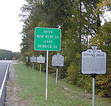 |
Long Bridge One mile south is Long Bridge over the Chickahominy River. Benedict Arnold sent Simcoe there in the British invasion of 1781. Longstreet crossed there in the Peninsular Campaign, May 1862. Grants Fifth and Second Corps crossed there, in June 1864, on the way to Petersburg. Virginia Conservation Commission 1947 New Kent Road This was the main road to Williamsburg in early days. Cornwallis, retiring eastward, used this road in June 1781. The confederates, retreating westward, passed over it in May 1862. Conservation & Development Commission 1937 (US Route 60 Markers) |
Long Bridge Marker -- The Long Bridge marker records the landing of the second invasion of Virginia about 20 miles south at Westover Plantation on the James River in January of 1781. It was from the plantation that Benedict Arnold marched on Richmond, but as noted by the Long Bridge marker, he sent Colonel Simcoe and his Queen Rangers north of the plantation. Their mission was to destroy the Colonists war-making industry, including a gunpowder factory and an iron foundry. At Charles City, they cornered a Virginia militia contingent, killing about 20 Americans.
New Kent Road Marker -- The New Kent Road marker records the passing of Cornwallis’ army. He marched his army numbering about 7,000 to Williamsburg passing through this area in June of 1781.
The markers not only indicate this area was a crossroad during the Revolutionary War, but also a crossroad 80 years later during the Civil War.
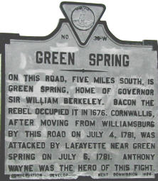 |
Green Spring On this road, five miles south, is Green Spring, home of Governor Sir William Berkeley. Bacon the Rebel occupied it in 1676. Cornwallis, after moving from Williamsburg by this road on July 4. 1781, was attacked by Lafayette near Green Spring on July 6, 1781. Anthony Wayne was the hero of this fight. Conversation Development Commission 1927 (US Route 60 Marker) |
Green Spring Marker -- Lafayette moved his forces through this area shadowing Cornwallis. Cornwallis was on the move to Portsmouth, about 20 miles to the east, carrying out orders from General Clinton to return 3,000 of his troops for the defense of New York City. Lafayette’s forces now numbered about 5,000 thanks to reinforcements sent by George Washington.
In order to reach Portsmouth, Cornwallis had to cross the
James River and he was well aware of the dangers of river crossings, especially
with Lafayette in the area. In an attempt to draw the American army into an
ambush, Cornwallis reversed the usual river-crossing procedures and sent his
army’s baggage first keeping the bulk of his forces hidden on the north side
of the river.
Lafayette did move in to attack what he thought was the British rear guard. His
advance American guard of about 500 men under the command of Anthony Wayne began
to skirmish with the British forces while Lafayette moved his troops into the
area. However, Lafayette didn’t fall into the trap. He personally
reconnoitered the British placement of troops and discovered the plot, but it
was too late to warn Wayne.
Cornwallis attacked Wayne with the full weight of his British
forces. Caught in the middle of an overwhelming ambush, Wayne led his tiny
American army on a bayonet counter-attack into a line of British troops facing
their musket fire, grapeshot and overwhelming odds. His furious counter-attack
stopped the British assault and he was able to escape with the bulk of his
forces.
In the battle, the British had about 75 casualties and the Americans twice that.
28 Americans were killed.
This part of US Route 60 is also called the Washington/Rochambeau Route. In a brilliant military decision, Washington quickly brought an Allied army, consisting of American and French forces from their offensive positions around New York City to this area in late September 1781 to join Lafayette and attack Cornwallis. The French forces were under the command of General Comte de Rochambeau.
In early August, prior to the arrival of the Allied army, Cornwallis had chosen Yorktown as his headquarters when he was directed to occupy a deep-water port that could be accessed by the British fleet. His orders to send 3,000 troops to New York from Portsmouth were countermanded.
While the allied army was on the move, a large French fleet under Admiral Comte de Grasse had sailed up from the West Indies and proceeded to blockade the mouth of the Chesapeake Bay. In the Battle of the Capes, de Grasse won a victory over Admiral Thomas Graves and his British fleet and on September 5th, proceeded to maintain a strict blockade, cutting off Cornwallis from help or escape by sea.