MOUNT INDEPENDENCEVERMONT |
 |
| US4 | NY5 | US7 | US9W | US20 | US60 | US202 | US221 | Canal |
MOUNT INDEPENDENCEVERMONT |
|
 |
Mount Independence In 1776, General Philip Schuyler identified this peninsula together with the old French fort across the narrows as the critical choke point for preventing the British from invading from the north. From July 1776 to July 1777, thousands of Americans garrisoned this site and Fort Ticonderoga. Just as construction of new artillery batteries was beginning here, news arrived that the continental congress declared independence. On July 28, 1776, Colonel Arthur St. Clair, the American brigade commander, read the Declaration of Independence to the assembled soldiers. After that day, East Point or Rattlesnake Hill, as this strategic height of land had been called, became known as Mount Independence. In July 1777, Burgoyne's British army forced the American troops to abandon this position. After the American evacuation, the British Army garrisoned the mount and continued work on the buildings and fortifications until November 1777 following the defeat of Burgoyne's army at Saratoga. The British rearguard burned all of the structures, abandoned the site and retreated to Canada. |
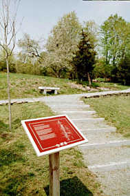
Mount Independence is designated a National Historic Landmark. The site is covered by several miles of hiking trails that wind past the remnants of batteries, blockhouses, hospital, barracks, and other archaeological remnants of this once-bustling fort complex. In the Visitor Center Museum, the story of military life atop the Mount is told in exhibits featuring many of the artifacts recovered during archaeological digs.
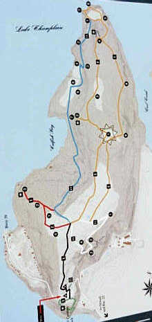
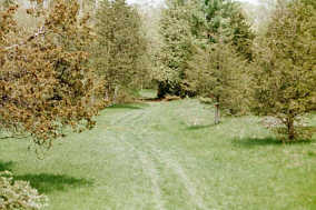
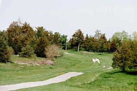
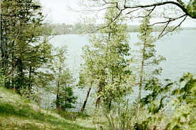
The four trails pass through nearly four hundred acres of pasture and woodlands with vistas overlooking Lake Champlain and the surrounding countryside. Each of the trails is color-coded, but if you don't pay careful attention, you can easily miss a turn and head-off in the wrong direction.
 |
Exploring Mount Independence As you explore the site, try to imagine a very different landscape during the fateful years 1776-1777. Today, Mount Independence is covered with trees and empty of structures of human habitation. During the American Revolution, the mount was a bare promontory on which all the trees had been cut. For sixteen months, it was alive with activity. Thousands of soldiers constructed fortifications and buildings with desperate haste. They lived in tents, huts and barracks, coped with miserable weather and disease, and prepared to meet the enemy. During the Revolutionary War, hundreds of soldiers from America, Britain and Germany died here from combat wounds, disease, poor diet and exposure. These dead lie in unmarked graves. Please remember their sacrifice by respecting the site. Do not search for artifacts or degrade the site. Enjoy the historical and natural beauty of this place. Leave it in the same condition for future visitors. Four marked trails lead you to the primary sites. A brochure is available to help you learn about the history of the site. |
The Fort on Mount Independence – In the summer of 1776, atop this rugged hill along the shore of Lake Champlain, American troops began building this fort complex to guard against a British attack from Canada. The troops named it Mount Independence in honor of the Declaration of Independence.
Unlike Fort Ticonderoga across the lake, the fort mainly consisted of huts and houses. A large shore battery and a horseshoe-shaped battery were completed. A picket fort was under construction.
As expected, the British did lead a counterattack in 1776. But thanks to delays caused by a fleet of naval ships under the command of Benedict Arnold and the combined impressive sight of Mount Independence and Fort Ticonderoga, British General Guy Carleton retreated to Canada, abandoning an attempted invasion that year. The very next year, 1777, the opposite would occur.
 Many
American troops went home the winter of 1776-1777, reducing the force from
12,000 to just 2,500. Those remaining spent a horrible winter at Mount
Independence. Many were sickly and a number froze to death.
Many
American troops went home the winter of 1776-1777, reducing the force from
12,000 to just 2,500. Those remaining spent a horrible winter at Mount
Independence. Many were sickly and a number froze to death.
In the spring of 1777, a few troops returned but not enough to properly garrison the forts. On July 5th, they evacuated the site when British General John Burgoyne's forces numbering about 8,000 began a penetration of the area. The evacuation was triggered by the astonishing placement of cannon on Mount Defiance. Fort Ticonderoga and Mount Independence were supposedly easy targets from the top of Mount Defiance.
As the Americans retreated, the British pursued them down the old military road, but were halted at Hubbard ton.
 The
Orange Trail – This trail is the longest trail at Mount Independence and
takes the better part of an hour to complete if you don’t take the battery
loop. Not taking the loop shortens the trail about a half-mile. All the trails
are recommended on a longer visit to the area.
The
Orange Trail – This trail is the longest trail at Mount Independence and
takes the better part of an hour to complete if you don’t take the battery
loop. Not taking the loop shortens the trail about a half-mile. All the trails
are recommended on a longer visit to the area.
The old military road leads to the beginning of all the trails. The orange trail continues to follow the road all the way out to the tip of the peninsula.
Station 1 – Barracks. The barracks were inside the picket fort or Star Fort that was the most imposing stronghold on Mount Independence. The fort was located at the highest point on the mount. The parade-ground clearing is still square, marked by cedars that have grown up along the lines of the barracks walls.
The trail meanders through some swampy areas on the mount. You can usually find boards on the ground or, in one case, a small bridge to get you across these areas.
|
|
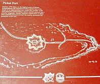
Picket Fort Here on the highest point of Mount Independence, the Americans built a picket fort in the shape of an eight-pointed star. Inside the wooden walls were barracks, grounds and a powder magazine. Abatis defenses, constructed of felled trees pointed outward towards the enemy, protected the perimeter of the fort. |
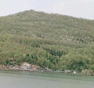
Station 2 – Crane. The crane that was at this location was used to lift cannon, heavy equipment and supplies from the lower shore 200 feet below. The loads were carried up a ramp from boats docked in the bay below. There is a warning sign: "Caution, High Cliffs. Use Care at Mast Point." From the "mast point," there is a terrific view of Lake Champlain with Mount Defiance in the background. But also, you can see where the LaChute River empties into Lake Champlain. Fort Ticonderoga is clearly visible to the right.
At the base of Mount Defiance is Route 22 and train tracks that are used by Amtrak trains from New York City to Montreal. The area is very quiet, except for the whistle of an occasional passing train.
Station 3 – Articifers' Shops. Articifers shops are those for blacksmiths, armorers, rope makers, wheelwrights, turners, shingle makers and others with indispensable skills. There is a sign on a tree that marks Station 3, but other than that, there are no physical remains that indicate where the shops actually were at this location.
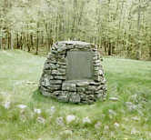
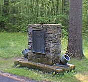
Station 4 – Horseshoe Battery. Horseshoe-shaped earthen walls enclose what was once a crescent-shaped gun platform. Inside this area is a stone memorial that was placed here by the Society of the Colonial Dames in 1963. The memorial is located where a Revolutionary War flagpole once stood. Cannon at this position commanded the lake to the north and the narrows separating Fort Ticonderoga from Mount Independence. This fortification is believed to be, at least in part, the work of Polish patriot Thaddeus Kosciusko, chief engineer at Saratoga and West Point.
|
|
In memory of the heroic garrison which gave this fortification its name on July 18, 1776. Erected by the National Society of the Colonial Dames of America in the State of Vermont. |
Back on the orange trail near station 4 is the intersection with the blue trail, the orange trail loop, and the returning orange trail. The orange trail loop winds around the tip of the peninsula. If you choose to take the loop, you will see Station 5 – Shore Battery, Station 6 – Bridge Site and Station 7 – Masting Point. All of these stations are located near the tip of the peninsula.
 The
shore battery was an extensive battery that guarded the vulnerable north shore
with numerous cannon. The bridge site is at the end of a slope that leads down
to the lake. The former floating bridge connected Mount Independence to Fort
Ticonderoga. The bridge was 12 feet wide and was anchored to 22 sunken piers
that have long since decayed and disappeared from the water.
The
shore battery was an extensive battery that guarded the vulnerable north shore
with numerous cannon. The bridge site is at the end of a slope that leads down
to the lake. The former floating bridge connected Mount Independence to Fort
Ticonderoga. The bridge was 12 feet wide and was anchored to 22 sunken piers
that have long since decayed and disappeared from the water.
The masting point is an outcropping of rock that is believed to be the spot where masts for boats in Arnold's fleet were stepped. The straight drop from this height into the water supports this theory. The climb back up to the intersection with the orange trail loop and the outgoing orange trail is somewhat of a physical challenge. One can only imagine what a challenge it must have been when poorly shod, American troops from Fort Ticonderoga retreated across the floating bridge under the cover of darkness with a full set of gear on July 5, 1777.
Station 8 – Observation Shelter. At the time of the revolution, this shelter would have had a commanding view of the East Creek.
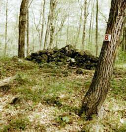 |
Observation Shelter Well-preserved L-shaped foundation possibly the remains of a look-out hut. |
Station 9 – Foundation. This rectangular foundation may have been a blockhouse overlooking East Creek. It is about 200 feet east of the stockade wall of the Star Fort.
The orange trail continues back to the military road, which leads back to the Visitor Center.
Enroute to Fort Ticonderoga, NY
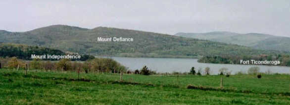
Norton's Farm. Behind the farm, you can see the area where the old military road once crossed Lake Champlain. Fort Ticonderoga is on the right; Mount Defiance is in the distance; to the left is Mount Independence.
Carillon Battlefield. The battlefield is where the French and the British battled for control of Fort Ticonderoga during the French and Indian War. Most of the markers and memorials in the battlefield pertain to the French and Indian War but some pertain to the Revolutionary War.
 |
Through this place passed General Henry Knox in the Winter of 1775 -1776 to deliver to General George Washington at Cambridge the train of artillery from Fort Ticonderoga used to force the British Army to evacuate Boston. Erected by the State of New York during the sesquentenial of the American Revolution. |
This marker has a map on it that shows the route taken by General Knox when he carried artillery from Fort Ticonderoga to Boston. The route includes Fort George, Fort Edward, Saratoga, Halfmoon, Albany, Kinderhook, Claverack, Nobletown and finally Cambridge.